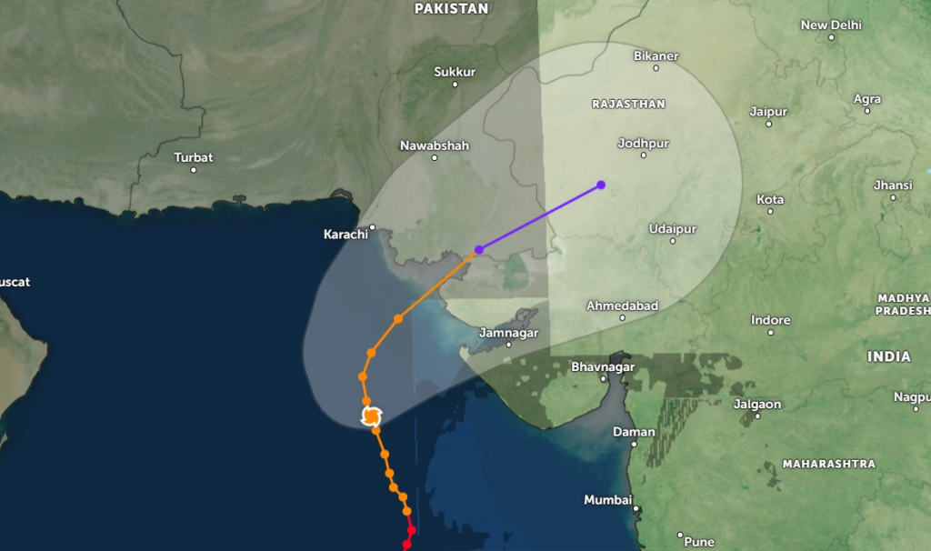
Islamabad June 13 2023: The Extremely Severe Cyclonic Storm “BIPARJOY” over northeast Arabian Sea moved further north-northwestward during last 12 hours and weakened into a Very Severe Cyclonic Storm (VSCS).
Under the existing upper-level steering winds, the VSCS “BIPARJOY” is most likely to track further Northward until 14 June morning, then recurve Northeastward and cross between Keti Bandar (Southeast Sindh) and Indian Gujarat coast on 15 June afternoon/evening as a Very Severe Cyclonic Storm (VSCS) with packing winds of 100-120Km/hour.
“BIPARJOY” now lies near Latitude 20.7°N & Longitude 67.1°E at a distance of about 470km south of Karachi, 460km south of Thatta.

Maximum sustained surface winds are 140-150 Km/hour gusts 170 Km/hour around the system center and sea conditions being phenomenal around the system center with maximum wave height 30 feet. The favorable environmental conditions (sea surface temperature of 29-31°C, low vertical wind shear & upper-level divergence) are in support to sustain its strength through the forecast period.
With its probable approach to the southeast Sindh coast, widespread wind-dust/thunderstorm rain with some very heavy/extremely heavy falls accompanied with squally winds of 80-100Km/hour gusting 120km/hour likely in Thatta, Sujawal, Badin, Tharparker, Mirpurkhas & Umerkot districts during 13-17 June.
Dust/thunderstorm-rain with few heavy falls accompanied with squally winds of 60-80 Km/hour likely in Karachi, Hyderabad, Tando Muhammad Khan, Tando Allayar, Shaheed Benazirabad & Sanghar districts from 14 -16 June.
Squally (high intensity) winds may cause damage to loose & vulnerable structures (Kutcha houses) including solar panels etc.
Storm surge of 3-3.5 meters (8-12 feet) expected at the land falling point (Keti Bandar and around) which can inundate the low-lying settlements.
Fishermen are advised not to venture in open sea till the system is over by 17 June, as the Arabian Sea conditions may get very rough/high accompanied with high tides along coast.


